The fort is surrounded by a series of ditches and ramparts, which would have made it difficult for attackers to breach the walls. Inside the fort, there are the remains of several roundhouses, which would have been used for living quarters. The site has been extensively excavated, and archaeologists have found evidence of pottery, tools, and other artifacts that give us a glimpse into the lives of the people who lived there.
Today, Chester’s Hill Fort is a popular destination for hikers and history enthusiasts. It is a fascinating site that provides a unique insight into Scotland’s ancient past. Whether you are interested in history or simply want to take in the stunning views, a visit to Chester’s Hill Fort is well worth the trip.
Location and Accessibility
Chesters Hill Fort is located in East Lothian, Scotland. The fort is situated just off the A198 road, which runs between North Berwick and Drem. It is easily accessible by car, and there is a dedicated car park for visitors to use.
The fort is open to the public year-round, and admission is free. Visitors can explore the site at their leisure, and there are information boards located throughout the fort that provide historical context and detail about the site.
For those travelling by public transport, the nearest train station is Drem, which is approximately 6 miles away from the fort. From there, visitors can take a taxi or bus to the site. The fort is also accessible by bus from North Berwick.
Chesters Hill Fort is located within the administrative areas of East Lothian Council and the East Lothian parish. The fort is situated in the former region of Lothian and Borders, the former district of East Lothian, and the former county of Haddingtonshire.
Historical Overview
The fort’s ramparts and defences consist of a stone and earth rampart with a ditch on the outside. The fort’s defences were constructed in several phases, with the earliest ramparts being built of timber and stone. The ramparts were later rebuilt in stone, and the ditches were deepened and widened.
The fort’s occupation is believed to have lasted until the Roman invasion of Britain in AD 43. The fort was likely a settlement for the Votadini tribe, who were a prehistoric people that inhabited the area.
Today, the fort’s ruined defences can still be seen on the top of Chesters Hill. The fort is a popular site for visitors and is included in the Atlas of Hillforts, a project that aims to map all hill forts in Britain and Ireland.
Architectural Features
Chester’s Hill Fort in East Lothian is a remarkable example of Iron Age architecture in Scotland. The fort is a complex structure, consisting of multiple circular houses and defensive walls. The architectural features of the fort are fascinating and provide insights into the construction techniques and inventory of the Iron Age.
The entrances to the houses were small and low, and the doorways were often covered with animal hides. This provided protection against the elements and helped to keep the houses warm. The inventory of the houses included pottery, tools, and weapons, which were essential for daily life.
The construction of the fort was a significant undertaking, requiring a great deal of labour and resources. The walls of the fort were built using dry stone construction, which involved stacking stones without the use of mortar. The walls were several metres high and would have provided excellent protection for the inhabitants of the fort.
The entrance to the fort was also an essential architectural feature. The entrance was protected by a gatehouse, which would have provided additional security for the fort. The gatehouse was constructed using timber and stone, and the entrance was narrow, making it difficult for attackers to enter the fort.
Excavations and Surveys
Chester’s Hill Fort in East Lothian has been the subject of several archaeological surveys and excavations over the years. These investigations have provided valuable insights into the history of the site and its use by various communities over time.
One of the earliest surveys of the site was conducted by the Royal Commission on the Ancient and Historical Monuments of Scotland (RCAHMS) in 1924. This survey recorded the location and extent of the fort, as well as identifying features such as ramparts and ditches. Aerial photography has also been used to map the site and identify cropmarks that may indicate the presence of buried structures or features.
More recent excavations have focused on uncovering the interior of the fort and understanding how it was used by its inhabitants. In 2012, a team from the University of Glasgow carried out a series of excavations that revealed the remains of several roundhouses, as well as evidence of metalworking and pottery production. These finds suggest that the fort was not only a defensive structure but also a thriving community with a range of specialist crafts and trades.
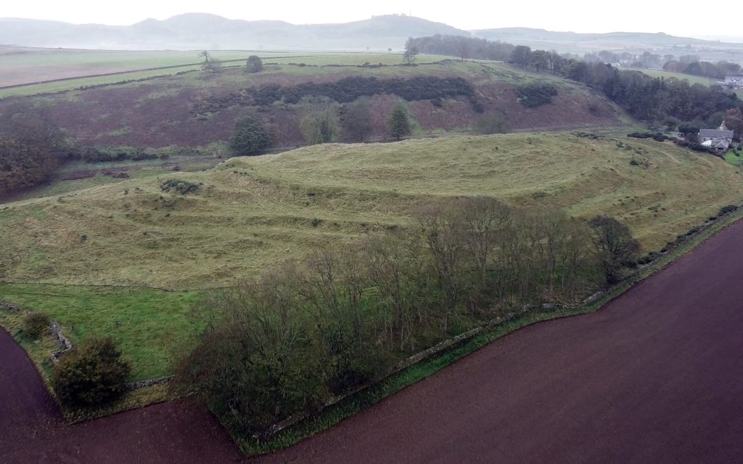
Geography and Topography
Chesters Hill Fort is located in East Lothian, Scotland, on a ridge known as Coll. The fort is situated on the northern slope of Traprain Law, overlooking the Forth to the south-west. The site is easily accessible from the west end of the ridge, where a car park is located.
During a field visit to the site, it was observed that the elevation of the fort is approximately 247 metres above sea level. The location of the fort provides an excellent view of the surrounding area, including the Forth and Fife to the north.
The fort is situated on a natural plateau, which has been enhanced by the construction of a rampart and ditch. The rampart is approximately 3 metres high and 10 metres wide, while the ditch is approximately 1.5 metres deep and 10 metres wide. The rampart and ditch encircle an area of approximately 0.5 hectares.
The fort is one of several Iron Age hill forts located in East Lothian and Great Britain. Other nearby hill forts include Kae Heughs and Kidlaw. The location of the fort suggests that it was strategically important for controlling access to the Forth and Fife.
Digital Collections and Resources
Chester’s Hill Fort is a historically significant site that has been the subject of numerous studies and excavations over the years. As such, there are many digital collections and resources available to those who wish to learn more about the fort and its history.
One of the most valuable resources for researchers and enthusiasts alike is the National Monuments Record of Scotland (NMRS) database. This database contains a wealth of information about Chester’s Hill Fort, including digital images of the site and its artifacts, as well as detailed descriptions and historical context.
Another useful resource for those interested in the fort is the East Lothian Council’s online archives. This collection includes a wide variety of historical documents and photographs, many of which relate to Chester’s Hill Fort and the surrounding area.
For those who prefer a more interactive experience, there are several virtual tours and 3D models available online. These resources allow visitors to explore the fort and its surroundings in detail, from the comfort of their own homes.
Preservation and Conservation
Preservation and conservation of Chester’s Hill Fort in East Lothian is of utmost importance to ensure that this monument remains intact for future generations to witness. Historic Environment Scotland, a government agency responsible for the protection and preservation of Scotland’s historic environment, oversees the preservation and conservation efforts at Chester’s Hill Fort.
To preserve and conserve Chester’s Hill Fort, a range of activities are undertaken. These include:
- Regular inspections to monitor the condition of the monument and identify any issues that need to be addressed.
- Conservation work to repair and stabilise any damage to the monument, such as erosion or weathering.
- Vegetation management to prevent the growth of plants and trees that could damage the monument.
- Public engagement to raise awareness of the monument’s significance and encourage responsible behaviour around it.